' You're doing WHAT in the rigging? '
sailship

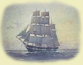
DUDLEY DIGGES, Captain of H.M.S.Deptford, looked up gloomily at the tightly swelling sails of his ship and then at the aft rail, where two hands were preparing to use a logline to estimate the ship's speed. The logline consisted of a flat piece of wood shaped like a sector of a circle, weighted at the bottom so that it floated upright. Attached to it was a long length of rope on a reel, knotted at 7 fathom (42 ft) intervals. At the end of the first 7 fathoms section there was one knot, after the next two knots, and so on. Also standing there was a midshipman holding a sandglass. One of the hands threw the log into the water. It hit the surface with a faint splash, and as the ship sailed away from it the hand carefully paid out the logline from the reel, which the other hand was holding aloft in his calloused fingers. The midshipman waited until a coloured piece of cloth tied onto the rope disappeared over the taffrail, and then he inverted the glass.
using the logline    The midshipman watched the sand grains trickle through the neck of the 30 second glass and eventually peter out. "Nip!" he piped in his yet-unbroken voice, and the old hand immediately stopped the line from paying out and bent to examine it.
   "Seven and an 'alf" he muttered to the boy, who ran to report this to the officer of the watch.
   "Beggin' your pardon, sir, seven and a half knots by the log" said the boy, raising his hand to his forelock in salute.
   "Very good, Mr Farrely", said Lieutenant Seward without a hint of a smile, and he turned to the first mate who carefully added this news to a long list of similar information on the slate next to the helmsman. The slate bore a record of all relevant information to do with the operation of the ship and especially with its movement through the water: speed, wind direction, bearing, time of bearing change, drift—all had a part to play in calculating the ship's position on the globe. Later this information would be transcribed to the ship's logbook.

Digges had overheard the exchange between Farrely and Seward. The logline method tended to overestimate speed slightly, which was sensible; if you weren't exactly sure how far you were from landfall, it was better to underestimate the time to get there rather than arrive at it unexpectedly in the middle of the night. Seven knots or nautical miles per hour was not a bad speed considering the conditions but he wished he could double it, for he feared discontent among the crew. Nine days ago he had slipped his moorings at Portsmouth and taken the Deptford through Spithead bound for Jamaica, but it wasn't very long before he discovered he had been cheated by the provisioners: much of the cheese and many barrels of beer were not fit for consumption. In a fit of pique and much to the consternation of the crew, Digges had ordered the barrels be thrown over the side. The crew would definitely not be happy with only water to drink on the voyage across the Atlantic.
   Digges had decided to make for Madeira, a tiny flyspeck on the map that was a Portuguese-administered island about 400 miles off the coast of Morocco, near the north-west tip of Africa. There he could get fresh provisions. The only trouble was, he first had to find it—not an easy task in the Year of Our Lord 1761, when navigation still involved a lot of estimation and guesswork about speeds, currents and drift. "Dead reckoning" (which some said evolved from ded., the abbreviation for "deduced reckoning") was anything but "dead accurate"; one could fix latitude (how far north or south of the equator) easily enough by measuring the angle between the horizon and the sun or the stars and then referring to a book of tables, but fixing longitude accurately was only possible by measuring the angle between the sun and the moon by day, or the moon and various stars at night, and then spending several hours working out some complicated formulae devised by astronomers. It was very easy to make a mistake, and you didn't have to be out by much to place yourself hundreds of miles from where you really were. And that was assuming you could see the celestial bodies. If the sky was overcast or it was foggy or raining, there was nothing you could do. No wonder so many ships foundered at sea—they often literally didn't know where they were.
   It was such a serious problem that the British Parliament had passed The Longitude Act in 1714, which offered a prize of £20,000 for a "Practicable and Useful" method of determining longitude to within half a degree; £15,000 for a method to within two-thirds of a degree; and £10,000 for a method to within one degree. To put this in perspective, half a degree of longitude spans 30 nautical miles (34 statute miles) at the equator—hardly pinpoint accuracy but it indicates how haphazard navigation was at the time. And no-one had managed to claim the prize in nearly 50 years.

 
Mr Seward, when I ask you our position I do not expect to be told: 'Somewhere in the middle of the Atlantic Ocean, Sir!' If only there was some way to accurately know what time it was at Greenwich, London (through which the arbitrary line of 0° longitude passes) whilst at sea, it would then be a simple matter to calculate one's longitude using the time difference between local noon and the Greenwich time. As an example, suppose that when it is noon locally, the time at Greenwich is 2.00pm. The time difference is thus 2 hours, or 120 minutes. Now, the earth revolves through 360° in 24 hours, so simple arithmetic tells us that the sun appears to travel 1° every 4 minutes. Our time difference is 120 minutes, therefore we are 120 ÷ 4 = 30° of longitude from Greenwich. But are we east or west of it? Since it was noon at Greenwich before it was noon locally, and the sun travels from east to west, we must be west of Greenwich. In fact, 30°W puts us somewhere in the middle of the Atlantic Ocean.


H1-click to enlarge


H4 - click to enlarge


All of the above presupposes having a clock that stays accurate while at sea. And since to win the £20,000 prize the method had to be proved on a journey from Great Britain to the West Indies—typically of six weeks' duration—the clock could not be out by a total of more than two minutes for the whole journey, or three seconds a day. This level of accuracy was unheard of for most clocks of the day, let alone one that had to perform at sea with all the various disturbances and temperature changes to contend with. Except, of course, for that curiosity Digges had heard about some time ago. In 1736, some 25 years earlier, a self-taught carpenter-cum-clockmaker called John Harrison had built a weird-looking device for keeping time at sea, and had managed to persuade the Admiralty into arranging a sea-trial on board H.M.S. Centurion on a run to Lisbon. The 'device' (for it didn't look much like a clock) was very large and heavy, and had occupied a large portion of the Captain's cabin, but apparently it had performed extraordinarily well—keeping time to within a few seconds a day. However, not much had been heard from Harrison since. Which brought Dudley to another reason for feeling gloomy.

Coming towards him across the freshly holystoned deck was a soberly-dressed man in his early 30's. William Harrison, son of John the Clockmaker, was on board to supervise a trial of his father's latest version of a sea-going clock. Digges was not especially fond of passengers. They got in the way of daily life aboard one of His Majesty's ships. They showed squeamishness and distaste whenever he had to order punishment for the crew for malingering, fighting or gambling. And worst of all, he had to entertain them at dinner in his cabin. Moreover, Harrison was not the only passenger on this trip—the Governor-designate of Jamaica, William Lyttleton, was also on board. And now Harrison was here for the daily ritual of winding the clock.

To ensure no possibility of underhand practice, the Commissioners of the Board of Longitude (the body established to administer and adjudicate the prize) had insisted that Harrison's clock be locked inside a wooden case that needed no less than four different keys to open it. Harrison had a key, as did Lyttleton, Digges and Seward. And every morning, regular as—well, clockwork—they all assembled in Digges' cabin to oversee the winding. Digges had been amazed the first time the case was opened and he saw the clock, nestled in the red velvet lining. It was more of an overgrown pocket watch than a clock, about 5" (12 cm) in diameter, with an exquisitely fine dial. Digges wondered how such a small thing could possibly be accurate enough to be useful in determining longitude. You were lucky if your pocket watch kept time to within 15 minutes a day, let alone a few seconds. Digges shook his head in disbelief.

Following the noon sighting, Digges made his customary dead reckoning calculations to work out his position. He made the longitude 13°50'W; Madeira he knew was 17°00'W. So there was still over 180 nautical miles to go—two days' sailing. The crew would not be happy.
'... a tiny flyspeck on the map... '
   Before long there was a knock at his cabin door. It was Harrison. Digges knew he would have made his own calculations regarding their position, using the Greenwich time shown on his father's clock.
   "Well, Mr Harrison, where do you put us?" In spite of his general dislike of passengers, Digges had time for the earnest young man; he tended to keep himself to himself and talked sparingly, having thought through first what he was going to say, in the manner of those from the north of England.
   "By your leave Captain, I make our longitude 15 degrees and 19 minutes west. I think we'll make Madeira by tomorrow morning." His tone was respectful but confident.
   "You do, do you?" mused Digges, rubbing his chin. If Harrison were right, that would put them approximately 90 nautical miles and one day's sailing closer to their destination than Digges, with all his years of nautical training, had calculated. He shook his head.
   "No, that can't be right," he said. "We won't see Madeira for two days, I'll lay odds on it."
   He was aware that Harrison was looking at him steadily, and that he had to make a decision: either lay a course for Madeira according to his dead reckoning, or put his trust in Harrison's confounded clock and lay a completely different course. If he chose the wrong one he could miss Madeira completely and sail for days without finding it. Not for the first time that journey did he feel a sense of foreboding settling over him.

Decisions, decisions...


next »